
Long Range Weather Forecast Discussion June 11-25
1456 PM EDT Sat. June 8, 2026
June 11-15: A ridge builds into the West with an upper low over Hudson Bay with a trough across the northern states. Some of the guidance indicates a ridge along the East Coast.
A broad upper trough across the northern states will push a front east and south, becoming the focus for thunderstorms and heavy rain across the upper Great Lakes and the Ohio Valley on Thursday. The front then stalls across the central states late in the week and will cause additional thunderstorms in the southern and central Plains and the lower and middle Mississippi Valley through the weekend and into early next week. An upper ridge over the East will support above normal temperatures late in the week and early next week. A ridge will build over the Northwest, resulting in above normal temperatures.
June 16-20: In general, expect a quasi-zonal across the country. Below normal heights will be across the northern states.
Low pressure lifts into Canada with a front extending to the Gulf on Tuesday. The front will be the focus for rain and storms. The next system track across the Great Lakes on Thursday will cause rain and possible storms. A system is organizing in the Plains on Friday, spreading rain and storms into the Midwest on Friday.
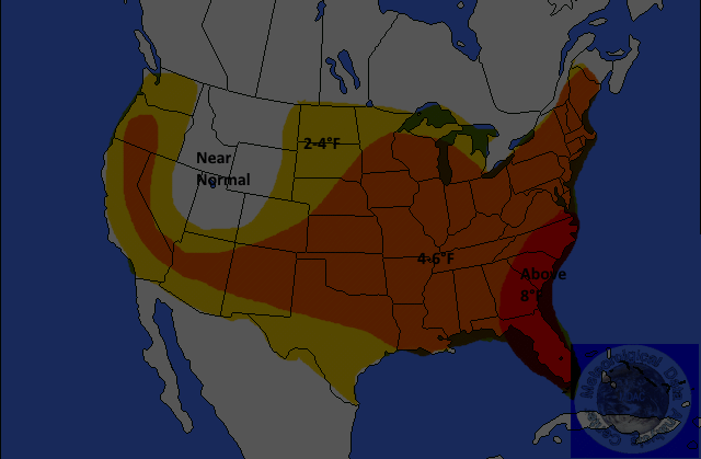
TEMPERATURES

Yellow-2-4°F Above
Orange-4-6°F Above
Red-6-8°F
or Greater Above
Light Blue 2-4F Below
Medium Blue-4-6F Below
Dark Blue-6-8F or Great Below
Above-normal temperatures are forecast for the West Coast States, and into the Four Corners, the southern Plains, and the East Coast States. Anomalies could be at least 6°F in some locations. Below normal temperatures are forecast for parts of the northern Rockies, the central and northern Plains, and parts of the Great Lakes region.
PRECIPITATION
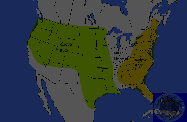
Yellow 35%Below
Brown-35-45% Below
Dark Brown-45-55% Below
Light Green-30-35% Above
Medium Green-35-45% Above
Dark Green-45-55%Above
Below normal precipitation is forecast for Northern California and the Northwest. The probability of occurrence is 35 percent. Above-normal precipitation is forecast for the Plains, most of the Mississippi Valley, parts of the Midwest, the Southeast, the Gulf Coast, and the lower Mid-Atlantic. The probability of occurrence is 40 percent.
June 21-25: The guidance is in good agreement on the flow for this period. The flow is expected to consist of a trough in the West and the Northeast with a ridge in between.
Rain and storms are forecast to continue across the Southeast. High pressure will be in control across the remainder of the East.
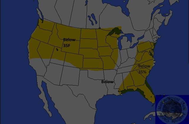
TEMPERATURES
Yellow-2-4°F Above
Orange-4-6°F Above
Red-6-8°F
or Greater Above
Light Blue 2-4F Below
Medium Blue-4-6F Below
Dark Blue-6-8F or Great Below
Above-normal temperatures are forecast for the Rockies to the Mississippi Valley. Anomalies could reach 6°F or more across the northern areas.
PRECIPITATION
Yellow 35%Below
Brown-35-45% Below
Dark Brown-45-55% Below
Light Green-30-35% Above
Medium Green-35-45% Above
Dark Green-45-55%Above